How to GPS Track Drivers
- Gord More (Unlicensed)
The GPS map in IDS does many things, from showing live locations of drivers to displaying all GPS history, calculating stop times and finding approximate addresses.
GPS
For GPS to work, a driver must have GPS turned on and logged into IDS's App with an active Data signal. If you need assistance, please see this article.
Accessing the map
The simplest way to access the GPS map from IDS is to open the Drivers window, right-click on a driver, and choose "Map Driver" from the menu.
Displaying drivers on the map
To display drivers on the map check the checkbox next to the driver's name. To center on a driver click the driver's name. To remove a driver from the map uncheck the checkbox. Multiple drivers may be displayed on the map at one time and will all update in real-time.
Viewing history for a driver
Today's history
To view today's recent history select the number of hours to go back from the dropdown next to the driver's name.
Previous day's history
To select a previous day:
- Choose the date from the top of the driver's list
- Enter the starting hour in 24hr format (ie. 1pm is 13) in the 24hr box
- Select the desired number of hours to view forwards from that point in the dropdown next to the driver's name.
Previous Day
Once a previous day has been viewed the dropdown hour selection moves ''forwards'' in time, instead of in reverse. Close and re-open the map to reset this behaviour
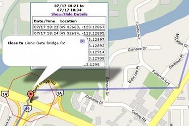
Driver stops
Every time a driver has stopped for more than 10 minutes in a 110 metre area a red octagon is drawn surrounding the area. Attached to the octagon is an info box showing the stopping and leaving time and a location pin which, when clicked, displays an ''approximate'' address of the location.
Address Shown
The address shown is an approximation only, ''not'' a definitive address. The location pin will be on the closest published road to the driver's location, not all private roads are listed.
Related articles